Complete Guide to Viae Turonensis
The Way of Tours (Via Turonensis) is the westernmost Jacobean route in France. From Paris (or Tours) to the Pyrenees, joining the French Way at Saint-Jean-Pied-de-Port or Roncesvalles.
Last updated: 28/03/2026
Table of Contents
Technical Summary of Viae Turonensis
913 km
Distance
38
days
36
Stages
Media
Difficulty
257 accommodations available on the route
Introduction to Viae Turonensis
All Stages of Viae Turonensis
Complete route divided into 36 stages
The City of Wood
This stage culminates in the monumental city of Tours, the heart of the Via Turonensis and Loire Valley. The route is long and demanding, but the profile eases as it approaches the Loire Valley. Arriv...
The Village of Bois - Étampes
This is one of the most emblematic stages of the French Way, the starting point for many pilgrims seeking to obtain the Compostela. The route is a continuous up and down through rural Galicia, with a ...
Étampes - Angerville
This stage continues through rural Galicia, with a profile that includes the ascent to the Ligonde Mountains, the highest point on the Camino in Galicia. It is a beautiful day that crosses forests and...
Artenay - Angerville
This is one of the longest stages at the end of the Camino Francés, an authentic nightmare with continuous ups and downs. The path traverses a beautiful landscape, with forests, rivers, and villages. ...
Artenuy-Orléans
The penultimate stage of the Camino Francés. The route is smoother than before, a pleasant stroll through eucalyptus forests and meadows. Emotion grows as you approach Santiago. It's a day to enjoy th...
Orleans-Beaugency
The last stage. Emotion is the protagonist of this journey. The path crosses the last forests before arriving at Monte do Gozo, from where you see the cathedral of Santiago for the first time. The ent...
Château de Beaugency - Château de Blois
The Queen Stage of the Pyrenees, one of the toughest and most beautiful stages on the Camino de Santiago. The ascent along the Napoleon Route is demanding but the views are spectacular. It's a high mo...
Blois - Chaumont-sur-Loire
After the harshness of the Pyrenees, this stage is a pleasant descent through Navarre's valleys. The road passes through beech trees and charming villages. It's a day to enjoy nature and recover stren...
Champtochester - Anjou
This stage brings the pilgrim to the first major city on the Camino Francés in Spain. The route is an enjoyable stroll along the Arga River valley. Arrival in Pamplona, the City of St. Fermín, with it...
Amboise to Tours
This stage is one of the most iconic on the French Way. The ascent to Alto del Perdón, with its famous monument to pilgrims, offers spectacular views. It's a day of great beauty and symbolism. Arrival...
Guided tours - Sorigny
This stage traverses medieval Navarre, on a broken-pavement route with continuous ascents and descents. The landscape is of great beauty, with vineyards, olive groves, and villages with charm. It's a ...
Saigny - Sainte-Maure-de-Touraine
Leaving behind the monumental Estella, this stage enters Navarre's more viticultural region. The route is of moderate distance and undulating profile, with the famous Wine Fountain at the Monastery of...
Saint Maure of Touraine - Dangé Saint Romain
This long stage marks the departure from Navarra and the entry into La Rioja. The route is demanding due to its distance, but the profile softens as it approaches the Ebro River valley. It's a beautif...
Dange-Saint-Romain - Châtellerault
Leaving behind the Riojana capital, this long stage enters into the heart of La Rioja Alta, one of the most famous wine-producing zones in the world. The route is a continuous up and down through a se...
Chatellerault - Poitiers
This stage continues through La Rioja Alta, on a moderate distance and gentle profile walk. The landscape remains dominated by the vineyards. It's a transition day with no major difficulties, allowing...
Poitiers - Lusignan
This stage marks the departure from La Rioja and the entry into Castile and León. The route is a pleasant stroll across the plain, with the Oca Mountains in the distance. It's a day of transition that...
Lusignan is a commune in the Oise department in northern France.
This is a mountain stage that crosses the Oca Mountains, a wooded and isolated area feared by medieval pilgrims. The ascent is demanding, but the landscape is of great beauty. It's a day to enjoy natu...
Chenay - Melle
After the mountain, the road descends gently towards the great city of Burgos. The journey passes through the Sierra de Atapuerca, a place of great importance for the history of humanity. Arrival in B...
Melun - Meaux
Leaving behind the monumental Burgos, this stage enters into the Castilian tableland. The route is flat and monotonous at times, a landscape of cereal fields and endless horizons. It's a day for intro...
Aulnay - Saint-Jean-d'Angély
This stage continues across the Meseta, with a profile that includes an ascent to Mostelares' high point, a balcony over the Castilian plain. It is a day of great scenic beauty. The arrival in Castroj...
Saints of Angély - Saintes
This stage enters the Tierra de Campos region, the heart of the Meseta. The route is flat and monotonous, a challenge for the pilgrim's mind. Arrival in Frómista is monumental compensation. Its church...
Saints - Ponts
This stage follows the course of the Canal of Castile, an impressive 18th-century engineering work. The route is completely flat and very pleasant. It's a day to enjoy the tranquility of the water and...
Ponts-sur-Nièvre and Mirambeau
This stage is one of the most representative of the Meseta, a 17 km long straight stretch along the ancient Roman road Vía Aquitania. The route is flat, monotonous and without shadows, an authentic me...
Mirabeau - Saint-Aubin-de-Blaye
This stage continues through the Land of Fields, on a route that combines sections of the ancient Roman road with paths between fields of cultivation. It's a day of great scenic beauty. The arrival in...
Saint-Aubin-de-Blaye is a commune in the Gironde department in southwestern France.
Leaving behind the monumental Sahagún, this stage enters into the Leoneser high plateaus. The route is flat and monotonous, a challenge for the pilgrim's mind. It is a journey for introspection and me...
Blaye - Blanquefort
This stage continues through the Leonesian highlands, on a flat and shadowless route. It's a day to enjoy the vastness of the landscape and the solitude of the road. The arrival in Mansilla de las Mul...
White Fort - Bordeaux
This stage is an enjoyable stroll that brings the pilgrim to the great city of León. The route is flat and follows part of the course of the Torío River. Arrival in León, with its impressive Gothic ca...
Bordeaux - Le Barp
Leaving behind the monumental lion, this long stage enters the Leonese highlands. The route is flat and monotonous, a challenge for the pilgrim's mind. Arrival at Hospital of Órbigo, with its impressi...
Barp - Saugnacq and Muret
This stage marks the transition from the Leonese highlands to the Maragatería region. The route is a pleasant walk over undulating terrain. Arrival in Astorga, a city with an impressive Roman and medi...
Saucagnacq-et-Muret - Labouheyre
Leaving behind the monumental Astorga, this stage begins the ascent to the León Mountains. The route is a continuous climb through the Maragatería region, with its stone villages and heather landscape...
Labouheyre - Onesse-Laharie
This is one of the most emblematic stages of the French Way. The ascent to Iron Cross, the highest point on the route, is a moment of great emotion and spirituality. After crowning, a long and vertigi...
Onees-Laharie Tower
Leaving behind the monumental Ponferrada, this stage enters the Bierzo comarca. The route is an enjoyable stroll over flat terrain, between vineyards and orchards. It's a day to enjoy the landscape an...
Height - Dax
This is the queen stage of entering Galicia, the mythical ascent to O Cebreiro. The route is a continuous climb through the Valcarce valley, which becomes harder in the last kilometers. It's a day of ...
Dax is a commune in the Pyrénées-Atlantiques department in the Nouvelle-Aquitaine region of southwestern France.
After the difficulty of climbing to O Cebreiro, this stage is a pleasant descent through the Sierra de los Ancares. The route passes through a beautiful landscape with forests and meadows. It's a day ...
Peyrehorade - Bergouey
This stage offers two variants, one for St. Xil and the other for Samos. Both are of great beauty. The Samos variant, longer, allows visiting the impressive Benedictine monastery. Arrival in Sarria, t...
Bergouey - Ostabat
The first stage of the Camino del Norte is one of the most beautiful and demanding. The path ascends to Mount Jaizkibel, offering spectacular views of the Cantabrian Sea and the Basque coast. It's a d...
Key Towns of Viae Turonensis
The most important towns and cities on this route.
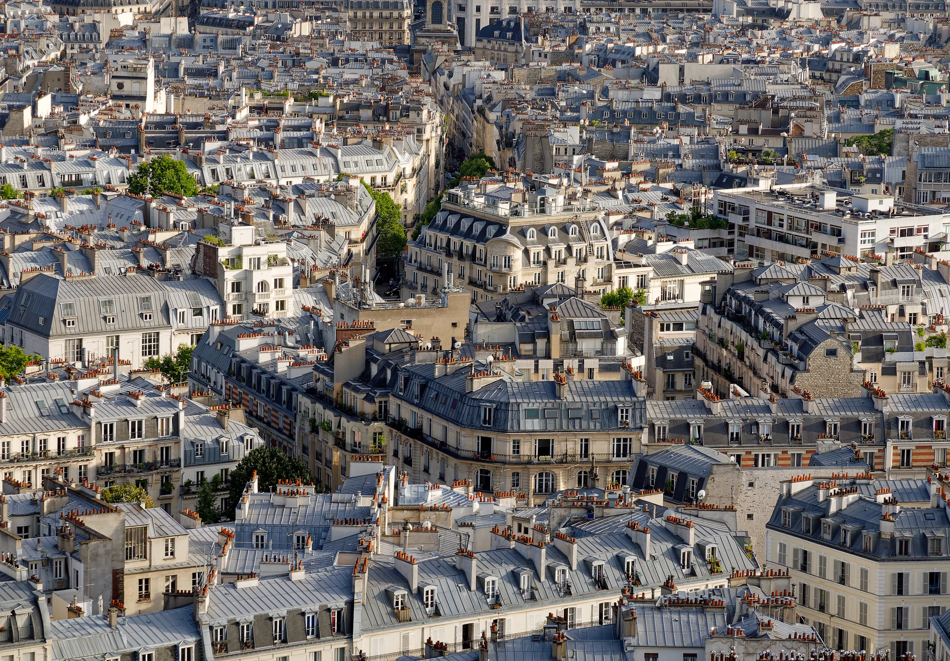
París
The City of Light is the starting point of the Via Turonensis, the longest Jacobean route in France. A monumental beginning for a pilgrimage that starts at St. James' Tower.

La Ville-du-Bois
80 mSuburb in the outskirts of Paris, first stop.

Étampes
75 mCity with a rich medieval heritage.

Angerville
140 mTown in the region of Beauce.

Artenay
125 mTown in the Beauce region near Orléans.

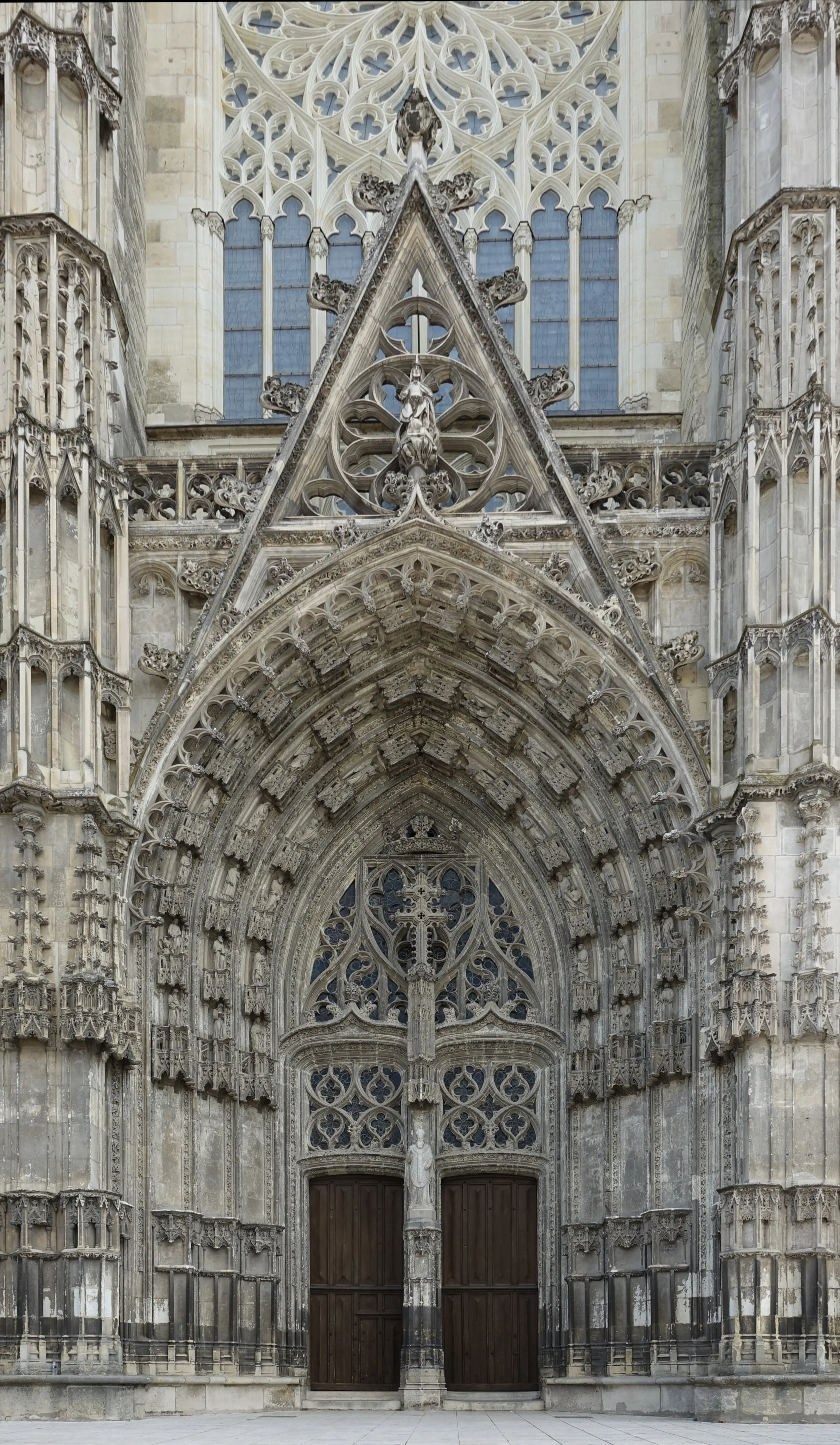
Orleans
City of Joan of Arc by the Loire River. Orleans is a key historic stop on the Via Turonensis, with an imposing Gothic cathedral and a rich medieval past.

Beaugency
90 mMedieval town with a historic bridge over the Loire.

Blois
70 mCity with a castle that is a summary of French architecture.

Chaumont-sur-Loire
70 mWell-known for its castle and International Garden Festival.

Amboise
65 mAmboína
Tours
Heart of the Loire Valley and city of Saint Martin. Tours, with its Gothic cathedral and old town, is the starting point of the Via Turonensis, one of France's major Jacobean routes.

Sorigny
90 mTown in the region of the Turena.
History of Viae Turonensis
The symbolic starting point of the route is the Tower of Santiago (Tour Saint-Jacques) in Paris. As the capital of the kingdom, Paris was an attraction that drew people from all walks of life, including pilgrims coming from northern France, Flanders, and England. From here, the route heads south, but its name, "Turonensis", does not come from Paris, but from its next major milestone: the city of Tours. During the High Middle Ages, Tours was one of the most important pilgrimage centers in Christendom, much earlier in popularity than Santiago. It housed the tomb of Saint Martin of Tours (died in 397), a saint whose fame was immense throughout Europe. For many pilgrims, the journey to Santiago was, in reality, an extension of their pilgrimage to Saint Martin. The Via Turonensis was, above all, the route to Tours.
After leaving Paris, the route passes through cities of great historical resonance such as Orleans, liberated by Joan of Arc, and ventures into the Loire Valley, a region of pleasant landscapes and unparalleled monumental wealth. After the obligatory stop at the Basilica of Saint Martin of Tours, the route continues south, passing through another important pilgrimage center, Poitiers, where relics of Saint Hilary were venerated. The route traverses the rich region of Aquitania, passing through Saintes, with its church of Saint Eutropius, and the great port city and wine-producing town of Bordeaux.
Unlike other French routes that are more mountainous, most of the Via Turonensis follows a relatively flat terrain, making it a less physically demanding option, although its length, over 900 kilometers, posed a challenge of endurance. It largely followed the route of ancient Roman roads, making it a principal means of communication, not just for pilgrims but also for travelers, armies, and merchants.
After crossing the vast forest of the Landes of Gascony, the pilgrim arrived at the Pyrenees. The Via Turonensis converged with those of Le Puy and Vézelay at Ostabat, to reach finally Saint-Jean-Pied-de-Port, the last French village before facing the legendary Roncesvalles pass and joining the Navarro route, which is already the beginning of the great Camino Francés in Spain.
Although it is less traveled today than the Via Podiensis (Way of Le Puy), its revival as a long-distance hiking trail, GR®655, has revitalized this historical itinerary. Today, to walk it is an immersion in French history, a journey that connects the capital with the city of devotion, passing by the tombs of some of the most revered saints in Christendom and traversing landscapes that are the heart of French culture.
Accommodations on the Route
The Viae Turonensis has 257 verified accommodations along the entire route.
View Stages & AccommodationsPractical Tips for Viae Turonensis
Best Season
Spring (April-June) and autumn (September-October) are the best seasons. Pleasant temperatures and fewer crowds than summer.
Physical Preparation
Train by walking progressively in the months before. Start with short distances and increase. Your body will adapt to the rhythm of the Camino.
What to Pack
Light backpack (max 10% of your weight), worn trekking shoes, breathable technical clothing, raincoat, sunscreen and basic first aid kit.
General Tips
Carry the pilgrim credential, stay hydrated, respect your pace, book accommodation in high season and enjoy the journey without rushing.
FAQ about Viae Turonensis
El Camino de Tours, conocido como Via Turonensis, tiene una longitud aproximada de 913 km desde París hacia los Pirineos. En Ourway Travel ofrecemos itinerarios detallados para que puedas prepararte adecuadamente.
El recorrido completo del Via Turonensis desde París hasta Saint-Jean-Pied-de-Port o Roncesvalles, donde se une al Camino Francés, suele durar entre 35 y 40 días aproximadamente. Ourway Travel te proporciona planes personalizados para que puedas disfrutar de cada momento del camino.
La temporada media, desde abril hasta junio y nuevamente en septiembre y octubre, ofrece las condiciones ideales para realizar el Via Turonensis. Durante este periodo hay un equilibrio entre climatología agradable y menor número de peregrinos que en la temporada alta (julio-agosto). En Ourway Travel te recomendamos esta época por su comodidad y belleza natural.
Los precios para realizar el Via Turonensis con nuestra agencia varían según las fechas, servicios incluidos y duración del viaje. En Ourway Travel gestionamos paquetes personalizados que pueden ir desde 1500€ hasta más de 2000€ por persona, dependiendo de los servicios adicionales seleccionados.
Con Ourway Travel, tu reserva para el Via Turonensis incluye alojamiento en albergues o casas rurales, traslado de equipaje entre etapas, asesoramiento personalizado y acceso a un servicio de apoyo 24/7 durante tu peregrinación. Además, te proporcionamos material informativo sobre el itinerario y consejos útiles para prepararte.
El Via Turonensis es una ruta única que ofrece un patrimonio monumental excepcional, atravesando regiones históricas de Francia como el Valle del Loira y Poitou. A diferencia de rutas más conocidas como el Camino Francés, el Via Turonensis brinda una experiencia cultural y religiosa más profunda, con menos afluencia de peregrinos. En Ourway Travel, te recomendamos esta ruta si deseas explorar una trayectoria alternativa con una historia rica.
El Via Turonensis es ideal para aquellos que buscan un camino menos transitado y lleno de riqueza histórica. Ofrece una experiencia cultural más intensa, pasando por ciudades emblemáticas como París y Tours antes de unirse al Camino Francés cerca de los Pirineos. En Ourway Travel te ayudamos a disfrutar de esta ruta alternativa con itinerarios cuidadosamente diseñados.
Para obtener tu credencial de peregrino, puedes visitar cualquier oficina de correos en Francia o solicitarla directamente con Ourway Travel. En nuestro servicio completo te proporcionamos toda la documentación necesaria incluyendo esta importante credencial que debes llevar durante todo el camino.
Ready for this adventure?
Let us organize your pilgrimage. We take care of accommodations, transfers and everything you need.